Cornwall has over 288 miles of coast path, open moorland on Bodmin Moor, and sheltered woodland valleys — enough walking to fill months without repeating a route. The coast path alone has a total ascent equivalent to almost four times Everest. Here are 15 walks graded by difficulty, with practical details for each.
Easy walks
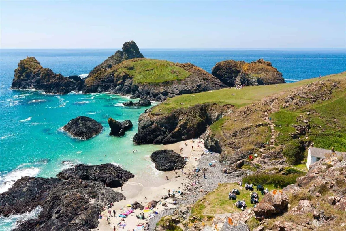
Kynance Cove to Lizard Point
3 miles one way | 1.5 hours | Lizard peninsula
One of the finest short walks in Cornwall. Start at Kynance Cove — serpentine rock stacks, turquoise water, and a cafe on the cliff — and follow the coast path south to Lizard Point, the most southerly point in mainland Britain. The path is well-maintained and mostly level with a few gentle inclines. Return the same way or continue to Cadgwith for a longer day.
Parking: National Trust car park at Kynance (pay and display). Pub stop: Top House Inn or Witchball at Lizard village. Dogs: Yes, year-round on the path. Kynance beach has seasonal restrictions.
Sennen Cove to Land’s End
4 miles return | 2 hours | West Cornwall
Follow the coast path from Sennen — one of Cornwall’s best surf beaches — south to Land’s End. The granite cliffs here are the westernmost point of mainland England. The path is straightforward and the views are vast: nothing but Atlantic ahead. On a clear day you can see the Isles of Scilly. Return the same way.
Parking: Sennen Cove car park. Pub stop: The First and Last Inn in Sennen, or the cafe at Land’s End. Dogs: Sennen beach allows dogs year-round on the northern section.
Maenporth to Swanpool, Falmouth
1.7 miles one way | 45 minutes | Falmouth
A short, gentle coast path walk between two sandy beaches near Falmouth. Pass through a nature reserve with birdlife along the way. Both beaches have cafes and are family-friendly. Short enough for small children. Walk one way and bus back, or return along the same path.
Parking: Maenporth Beach car park. Dogs: Both beaches are dog-friendly year-round.
Camel Trail: Wadebridge to Padstow
5.5 miles one way | 2 hours walking, 1 hour cycling | North Cornwall
A flat, surfaced path along a disused railway following the Camel Estuary. Suitable for pushchairs, wheelchairs, and all fitness levels. The estuary views widen as you approach Padstow. Bike hire is available at both ends — most people cycle it in an hour. Dogs welcome on leads (shared with cyclists).
Parking: Wadebridge town car parks, or Padstow. Pub stop: Multiple in Padstow — finish with fish and chips on the harbour.
Crantock Beach circular
2.5 miles | 1 hour | Near Newquay
A family-friendly loop from Crantock car park, down to the beach, along the Gannel estuary, and back via the coast path. The beach has an estuary for paddling and rock pools at low tide. Flat and easy. Dogs welcome year-round.
Parking: Crantock Beach car park (National Trust).
Moderate walks
Bedruthan Steps to Mawgan Porth
4 miles one way | 2 hours | North Cornwall
Giant sea stacks rise from the beach at Bedruthan Steps — one of the most photographed stretches of the Cornish coast. Follow the coast path south to Mawgan Porth, passing clifftop wildflowers in spring and summer. Some steep sections but nothing extreme. The beach at Bedruthan is accessible by steps at low tide only.
Parking: National Trust car park at Bedruthan Steps. Pub stop: The Merrymoor Inn at Mawgan Porth. Dogs: Year-round on the path and Mawgan Porth beach.
St Agnes to Chapel Porth
3 miles one way | 1.5 hours | North Cornwall
Walk through the heart of Cornwall’s mining heritage. Ruined engine houses perch on clifftops above the sea — this is a UNESCO World Heritage landscape. The terrain is moderate with some inclines. Chapel Porth has a small beach cafe that serves hedgehog ice cream (vanilla rolled in clotted cream and hazelnuts).
Parking: St Agnes village or Chapel Porth National Trust car park. Pub stop: The Taphouse or the Peterville Inn in St Agnes.
Looe to Polperro
5.4 miles one way | 3 hours | South-east Cornwall
A richly varied walk along the south coast between two fishing harbours. Rock pools, a 6th-century monastic site, and views of shipwrecks along the way. Polperro at the far end is car-free in summer — a narrow valley village with a working harbour. Regular buses run back to Looe.
Parking: Looe town car parks. Pub stop: The Blue Peter Inn in Polperro (harbourside, dogs welcome).
Mullion Cove to Lizard Point
7 miles one way | 3.5 hours | Lizard peninsula
A longer walk across the Lizard’s dramatic south coast, passing Kynance Cove partway. The path crosses serpentine rock — unusual geology found almost nowhere else in Britain — with turquoise water below and rare wildflowers on the clifftops. The final stretch to Lizard Point is the most southerly walking you can do on the British mainland.
Parking: Mullion Cove car park. Pub stop: Cadgwith Cove Inn (short detour off route), or Top House at Lizard.
Boscastle to Tintagel
5 miles one way | 2.5 hours | North Cornwall
From the harbour at Boscastle — where the valley narrows to a dramatic inlet — north along the cliffs to Tintagel Castle. The path passes Rocky Valley (a narrow gorge with ancient rock carvings) and St Nectan’s Glen. Tintagel’s castle ruins and Merlin’s Cave are at the far end. Regular buses connect the two.
Parking: Boscastle main car park. Pub stop: The Cobweb Inn in Boscastle or Tintagel Arms.
Challenging walks
St Ives to Zennor
6 miles one way | 3-4 hours | West Cornwall
One of the toughest and most rewarding short walks in Cornwall. The path leaves St Ives along the cliffs and crosses granite moorland that drops steeply to the sea. Rocky, boggy in places, and with serious ascents. The views are extraordinary — wild, empty coast with no development. Finish at the Tinners Arms in Zennor and bus back to St Ives.
Parking: St Ives (park and ride recommended). Pub stop: The Tinners Arms, Zennor. Not suitable for: Young children, anyone uncomfortable with exposed cliff paths.
Tintagel to Port Isaac
10 miles one way | 5-6 hours | North Cornwall
The path climbs and drops repeatedly along one of the wildest stretches of the north coast. Steep descents into valleys followed by steep climbs out — the total ascent rivals a day in the mountains. The coast is largely undeveloped, with deserted coves accessible only on foot. Arrive at Port Isaac harbour exhausted and walk straight to a pub. Bus back to Tintagel.
Parking: Tintagel visitor car park. Pub stop: The Golden Lion, Port Isaac (harbourside).
Bude to Boscastle
16 miles one way | 7-8 hours | North Cornwall
The most dramatic and demanding day walk on the Cornish coast path. The terrain between Bude and Boscastle is relentless — deep valleys, vertical climbs, exposed cliff paths, and very few places to resupply. The scenery is extraordinary, with waterfalls, shipwreck remains, and folded rock formations. Only attempt this if you are fit, well-equipped, and prepared for a full day.
Parking: Bude town car parks. Pub stop: The Napoleon Inn or Cobweb Inn in Boscastle at the finish.
Inland walks
Cardinham Woods
1-4 miles (multiple trails) | 30 mins to 2 hours | Near Bodmin
A sheltered valley of mixed woodland near Bodmin — ideal when the coast is too exposed. Multiple waymarked trails of varying length. A stream runs through the centre (children gravitate to it). Pay-and-display car park, toilets, cafe, and a play area. Dogs off-lead on most trails. Works in any weather.
Bodmin Moor: Rough Tor
4 miles return | 2 hours | Central Cornwall
Walk from the car park near Camelford to Rough Tor (400 metres), Cornwall’s second-highest point. Open moorland with granite tors, wild ponies, and views across the county. The summit is a Bronze Age settlement site. On a clear day you can see both coasts. Continue to Brown Willy (420 metres, Cornwall’s highest point) if you want a longer walk. Keep dogs on leads — free-roaming livestock on the moor.
Parking: Free car park off the minor road south of Camelford.
Practical tips
Footwear. Coastal paths are rocky and uneven. Walking boots with ankle support are essential on moderate and challenging routes. Easy walks and the Camel Trail are fine in trail shoes or sturdy trainers.
Tides. Several beaches on walking routes are only accessible at low tide — Bedruthan Steps, some coves between Tintagel and Port Isaac, and St Michael’s Mount causeway. Check tide times before setting out.
Weather. Cornwall is milder than most of the UK but exposed to Atlantic weather. Carry waterproofs even on clear mornings. Wind on clifftops can be strong — keep children and dogs close to you.
Water. Carry water on coastal walks. There are few taps or streams on exposed clifftop sections, especially on the north coast.
Return transport. Most linear walks can be done as one-way trips with a bus return. First Kernow buses run along both coasts. Check timetables in advance — services reduce in winter.
Season. April to May brings wildflowers and bluebells on the cliffs. September and October have warmer sea temperatures and dramatic light. Winter is quiet and viable — Cornwall rarely freezes — but expect rain and shorter days.
For more on what to do in Cornwall, see our complete guide to things to do or browse beaches and attractions.
This guide is updated regularly. Last reviewed March 2026.