Cornwall is roughly 80 miles from top to bottom — Bude to Land’s End — but you won’t cover it quickly. The A30 dual carriageway runs through the middle, and most of the good stuff sits on single-track lanes that wind between hedgerows taller than your car. This itinerary works anticlockwise from the north coast down to the south, spending a night in each area. Seven days lets you see the lot. Three days means choosing favourites.
Before you go: driving in Cornwall
Narrow lanes. Most roads off the A-roads are single-track with passing places. Pull left to let oncoming traffic through. Mirrors will get tested — tuck them in on the tightest lanes. If you’re in a hire car, check the excess cover includes wing mirrors.
Parking. Cornwall’s car parks are almost all pay-and-display. Expect to pay £3–8 per day. National Trust members park free at NT car parks (Kynance Cove, Bedruthan Steps, Godrevy, and others). Download the JustPark and RingGo apps — many car parks are cashless.
Fuel. Fill up in larger towns. There are no fuel stations between Penzance and the Lizard, and none on the Roseland peninsula. Supermarket fuel in Truro, Newquay, and Penzance is cheapest.
Speed. National speed limit signs on Cornish lanes do not mean 60mph is sensible. Many bends are blind. Locals drive fast but they know the roads. Keep to 30–35mph on unfamiliar single-track lanes.
The 7-day itinerary
Day 1: Arrive — North Cornwall (Tintagel, Boscastle, Padstow)
Driving: 30 miles total | ~1 hour on the road
Start at Tintagel, where the headland drops 300 feet to the sea and Tintagel Castle clings to the cliff edge. English Heritage rebuilt the footbridge linking the mainland to the island in 2019 — the crossing alone is worth the visit. Adult entry is around £16; book online for a discount. Allow 2 hours.
Drive 4 miles (6 minutes) east to Boscastle, a narrow harbour valley that channels the River Valency to the sea. Park at the top car park and walk down. The harbour wall dates from 1584 and the village was rebuilt after devastating floods in 2004. Good lunch at the Napoleon Inn.
Head southwest 24 miles (30 minutes) to Padstow, your base for the night. Walk the harbour, eat fish and chips from Choughs Bakery or Rick Stein’s chippy on South Quay. Padstow’s restaurants book up fast in summer — reserve dinner early.
Where to stay: Padstow or Rock (a short ferry ride across the Camel Estuary).
Day 2: Padstow area → Newquay
Driving: 25 miles total | ~45 minutes on the road
Morning: walk or cycle the Camel Trail from Padstow to Wadebridge — 5.5 miles on a flat, surfaced path along the estuary. Bike hire is available at both ends (roughly £15–20 for a half day). Alternatively, drive 10 minutes to Constantine Bay for a morning on the sand.
Stop at Bedruthan Steps en route south. The National Trust car park sits on the clifftop; from there, look down at enormous sea stacks rising from the beach. The beach itself is only accessible at low tide via steep steps — check tide times before descending.
Continue to Mawgan Porth and then on to Newquay (21 minutes from Padstow). Newquay has Cornwall’s densest cluster of beaches — Fistral for surfing, Towan Beach by the harbour, Crantock for families. Fistral Surf School and others offer 2-hour lessons from around £35.
Where to stay: Newquay or Watergate Bay (3 miles north, quieter).
Day 3: Newquay → St Ives
Driving: 30 miles | 40–45 minutes direct
Take the coast road via St Agnes and stop at Trevaunance Cove — a former harbour hemmed in by cliffs with good surf. Walk the clifftop path to Wheal Coates engine house, one of the most photographed mining ruins in Cornwall, perched above Chapel Porth beach.
Continue to Godrevy, where the lighthouse that inspired Virginia Woolf’s novel sits on an island offshore. Godrevy Beach and the Towans run for 3 miles — enough space that it rarely feels crowded, even in August.
Arrive at St Ives in the afternoon. Park at the Trenwith car park (well signposted from the A3074) or — better — park at Lelant Saltings and take the branch-line train into town (10 minutes, runs every 30 minutes). St Ives charges premium parking rates in summer and spaces fill early.
Tate St Ives sits directly above Porthmeor Beach. The Barbara Hepworth Museum is a 5-minute walk away. Between them, allow 2–3 hours. For dinner, Porthminster Beach cafe does excellent seafood, or try the Sloop Inn on the harbour for pub food.
Where to stay: St Ives (book well ahead in summer) or Carbis Bay (1 mile east, less hectic).
Day 4: St Ives → Penwith (Land’s End, Sennen, Mousehole, Penzance)
Driving: 35 miles loop | ~1.5 hours on the road
This is the wild western tip of Cornwall. Drive from St Ives toward Land’s End via the B3306 through Zennor — a winding single-track route with moor to one side and Atlantic to the other. Zennor church has a medieval mermaid carving on one of its bench ends, worth a 5-minute stop. The full drive takes about 35 minutes.
At Land’s End, skip the theme park and walk 5 minutes along the coast path in either direction. On a clear day you can see the Isles of Scilly, 28 miles out. Drive 5 minutes to Sennen Cove — a proper Atlantic surf beach with a lifeguard station and a good cafe at the top of the slipway.
Loop east on the B3315 through Porthcurno. The Minack Theatre is carved into the granite cliff 200 feet above the sea — check the schedule for evening performances (May–September). Below it, Porthcurno Beach has white sand and clear water.
Continue through Lamorna to Mousehole (pronounced “Mowzle”), a tight harbour village with stone cottages right on the water. Then 3 miles further to Penzance. Walk Chapel Street for independent shops and the Turk’s Head pub, which dates from 1233.
From neighbouring Marazion, walk the causeway to St Michael’s Mount at low tide (or take the boat at high tide). The castle and subtropical gardens sit on the tidal island. Allow 2–3 hours.
Where to stay: Penzance or Marazion (for views of the Mount).
Day 5: The Lizard (Kynance Cove, Cadgwith, Coverack)
Driving: 40 miles | ~1.5 hours on the road
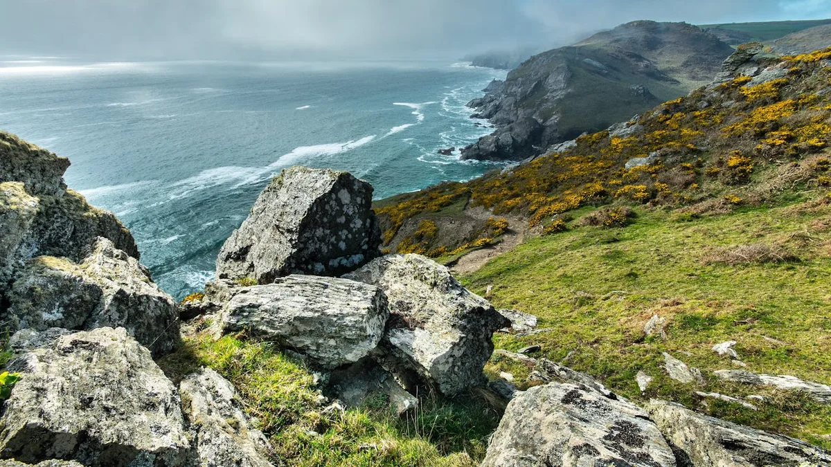
Drive from Penzance to the Lizard peninsula (35 minutes, 25 miles). This is mainland Britain’s most southerly point, and the landscape shifts noticeably — flat heathland, dark serpentine rock, and a wilder feel than the tourist-heavy north coast.
Start at Kynance Cove — serpentine stacks, turquoise pools, and a cafe on the cliff. Park at the NT car park at the top and walk down (10 minutes). The cove is tidal; check times or you’ll find a narrow strip of sand instead of the full beach.
Drive (or walk the coast path, 3 miles) to Lizard Point itself. The old lifeboat station at the bottom of the cliff is now a cafe. Continue east to Cadgwith, a fishing village with thatched cottages and pilchard cellars. The Cadgwith Cove Inn does crab sandwiches on the terrace.
Loop further east to Coverack, a quiet harbour village with a stone beach and rock pools. Then head north through Goonhilly Downs — home to the satellite tracking station that received the first transatlantic TV broadcast in 1962 — and on to Mullion or Helston for the night.
Where to stay: Mullion (close to the coast) or Porthleven (strong food scene — the harbour has 3 restaurants within 100 metres of each other).
Day 6: South coast (Falmouth, St Mawes, the Roseland)
Driving: 30 miles | ~1 hour on the road (plus ferry)
Drive to Falmouth (30 minutes from the Lizard area). Falmouth has the third-deepest natural harbour in the world and a proper working-town feel. Spend the morning at the National Maritime Museum on the waterfront or walk the coast path from Gyllyngvase Beach to Swanpool (20 minutes each way).
Pendennis Castle guards the harbour entrance — Henry VIII built it in 1540 to defend against French and Spanish invasion. The views from the ramparts cover the whole Fal estuary.
Take the passenger ferry from Falmouth’s Prince of Wales Pier to St Mawes (20 minutes, runs every 30 minutes in summer). St Mawes is a small, well-heeled village on the Roseland with a harbour-front castle and good pubs. The ferry saves a 29-mile drive around the river.
Drive deeper into the Roseland to Carne Beach or Pendower Beach — long, quiet stretches of sand that feel genuinely remote, even in peak season.
Where to stay: Falmouth (widest choice) or St Mawes (quieter, pricier).
Day 7: Mevagissey, Lost Gardens of Heligan, Eden Project, Fowey
Driving: 45 miles | ~1.5 hours on the road
Head east to Mevagissey, a working fishing harbour where boats still land crab and lobster daily. The inner harbour dries at low tide, leaving boats propped on the mud. Walk the harbour wall and grab a pasty from one of the bakeries on the quay.
Drive 4 miles to The Lost Gardens of Heligan, where 200 acres of Victorian gardens were abandoned in 1914 when the estate’s gardeners left for the Western Front. The jungle garden, productive gardens, and wild woodland walks take a solid 3 hours to cover properly.
Continue 10 miles (20 minutes) to The Eden Project, built in a former clay pit near St Austell. The two biomes — rainforest and Mediterranean — house plants from around the world under geodesic domes. Book tickets online in advance; summer days sell out. Allow 3–4 hours.
End the trip at Fowey (20 minutes south from Eden), a deep-water harbour town on the River Fowey. Narrow streets drop steeply to the waterfront. Readymoney Cove is a short walk from the town centre. The Old Quay House does excellent evening meals overlooking the estuary.
Where to stay: Fowey, or head east toward the A38 if you’re driving home.
The 3-day condensed route
If a week isn’t possible, this compressed version hits the three distinct faces of Cornwall. Total driving across all 3 days: roughly 120 miles.
Day 1: North coast
Morning at Padstow — harbour walk, lunch, Camel Trail cycle if time allows. Afternoon at Bedruthan Steps and Newquay (Fistral Beach or Crantock). Drive to St Ives for the evening (40 minutes from Newquay). Stay in St Ives.
On the road: ~1 hour 15 minutes
Day 2: West Cornwall
Sennen Cove and Land’s End in the morning. Porthcurno and the Minack Theatre mid-morning. St Michael’s Mount in the afternoon (check tide times for the causeway). Drive to Falmouth for the evening (30 minutes from Penzance). Stay in Falmouth.
On the road: ~2 hours
Day 3: South coast
Morning in Falmouth — National Maritime Museum or coast path walk. Drive to The Eden Project (50 minutes). Afternoon at Eden, then finish at Fowey or Charlestown harbour before heading home via the A38.
On the road: ~1 hour 30 minutes
You’ll miss the Lizard, Boscastle, and the Roseland — save those for a return trip.
Practical tips
Best direction. Anticlockwise (north coast first, then south) works better because you tackle the busier tourist stretch of Padstow–Newquay–St Ives early, leaving the quieter south coast for later when you’ve settled into the rhythm.
Fuel budget. The full 7-day route covers roughly 235 miles of driving. At average UK fuel prices, budget £40–55 for a standard car.
Supermarket stops. Tesco and Sainsbury’s in Newquay, Truro, Penzance, and Falmouth. There’s a Lidl in Penzance. Smaller towns have Co-ops and Spars but limited fresh food.
Mobile signal. Coverage drops out across the Lizard, parts of the Roseland, and rural north Cornwall. Download offline maps before you leave — Google Maps lets you save Cornwall as an offline region.
Timing. Start each day by 9am to beat car park queues at popular spots. Kynance Cove, St Ives, and Padstow car parks all fill before 10:30am in July and August. Late afternoon — after 4pm — is a good second window when day-trippers head home.